 |
      |
| Home > Virginia > Rocky Run |
Rocky Run ATV Trail
Wednesday, August 6, 2025
| Other Names | Rocky Run, Second Mountain, Dictum Ridge, George Washington & Jefferson National Forests, North River Ranger District, Rockingham County |
| Last Known Status | Temporarily Closed (closed due to ongoing construction of electricity transmission line) |
This area offers a 10 mile long narrow and rocky 4x4 loop that offers scenic mountain views of Second Mountain and the City of Harrisonburg. The trail is marked with orange blazes and primitive camping is permitted alongside the trail but not at the trailhead.
RVs and long campers are not advised due to the main entrance road (FDR 72) being very narrow with few turnouts and limited parking at the staging area.
The trail is open year-round and is very popular with Jeeps and ATVs.
REGULATIONS
| Permit Required | No | |
| Dates Open | Year-Round | |
| Other ATV Stickers Accepted | Unknown | |
| Spark Arrestor | Yes | A spark arresting exhaust silencer or end cap is required for all vehicles. |
| Noise Limit | Yes (96 dB) | |
| Whip Flags | Not Required | |
| Maximum Vehicle Width | No Restriction | |
 Motorcycles & Dirt Bikes Motorcycles & Dirt Bikes | Permitted | |
 ATVs ATVs | Permitted | |
 UTV & SXS UTV & SXS | Permitted | |
 SUVs & Jeeps (registered) SUVs & Jeeps (registered) | Permitted | |
| Dune Buggy & Sand Rail 4x4 (unregistered) | Permitted | |
| 2 Stroke Engines | No Restriction | |
| MX Helmet Required | Yes | helmets required by state law |
 Camping Camping | Some Areas | permitted alongside trail but not at trailhead |
 Campfires Campfires | ||
| Night Riding | Unknown | |
| Trail Blazing | Prohibited | keep vehicle on trail |
| Rule Enforcement | ||
| Comment | Trailers must not exceed 16 feet due to space limitations at staging area. Camping is not permitted within 500 feet around staging area or trailhead and within 200 feet of any stream. | |
TERRAIN
| Approx Size | 3,500 acres (5 sq mi) | |
| Miles Of Trail | 10 | |
| Climate Type | Forest | |
| Elevation | 2000 to 3200 ft. | |
| Trail Maintenance | Marked, Not Rated, Lightly Maintained | |
| Loose Dirt |  Little Little | |
| Hard Pack |  Some Some | |
| Sand |  None None | |
| Mud | Little | |
| Dust | Little | |
| Rocks | Some | |
| Trees |  All All | |
| Steep Hills | Some | |
| Small Jumps | None | |
| Large Jumps | None | |
| Berms | None | |
| Sand/Gravel Pits | None | |
| Single Track | None | |
| Intersections |  Few Few | |
| Rider Traffic | Some | |
| Hazards | Few | (hazards assumed marked but use caution) |
 Novice Novice |  Mostly Mostly | |
 Amateur Amateur | Some | |
 Expert Expert | Little |
TYPE OF AREA
| Area | Motorized Trails |
| Land | National Forest |
GPS POINTS


KEY SERVICES
 Gasoline Gasoline | 5-20 Miles (SE) | Shell (540) 433-6694 |
| Diesel | 5-20 Miles (SE) | Shell (540) 433-6694 |
 Water Water | 30+ Miles (NE) | Endless Caverns & RV Resort (800) 544-2283 |
 RV Hookup RV Hookup | 30+ Miles (NE) | Endless Caverns & RV Resort (800) 544-2283 |
 RV Disposal RV Disposal | 30+ Miles (NE) | Endless Caverns & RV Resort (800) 544-2283 |
| Campground | 5-20 Miles (W) | Brandywine Recreation Area (540) 432-0187 |
 Conv Store Conv Store | 5-20 Miles (S) | Mc Dorman's Grocery (540) 867-0074 |
FEES & PASSES
| Parking | (None) |
| Entry | (None) |
| Riding | (None) |
| Camping | (None) |
RATINGS
| Our Rating |  Very Good Very Good |
| Recommended Stay | 1-2 Days |
| Comments | (Scroll Down For Rider Reviews & Comments) |
DRIVING DIRECTIONS
| Nearest City | Harrisonburg, VA | ||
| Address | Long Run Road, Harrisonburg, VA 22802 | ||
| From: Harrisonburg, VA
1) Take US-33 West about 12 miles 2) Turn right (north) on Rt. 612, continue 4.5 miles 3) Turn left (west) on FDR 72/Long Run Road (look for Gospel Hill Church), continue 6 miles 4) At top of FDR 72/Long Run Road, turn left (south) onto Second Mountain Trail, continue about one mile toward staging area (*see warning below). *Note: The last mile on Second Mountain Trail is now covered with 4" bluestone gravel that could possibly damage regular street tires if not careful. Use caution. |


OFFICIAL CONTACTS
| Contact Info | George Washington National Forest - North River Ranger District 401 Oakwood Drive Harrisonburg, VA 22801 (540) 432-0187 (866) 904-0240 mailroom_r8_george_washington_jefferson@fs.fed.us www.fs.usda.gov |
Rocky Run Trail Photo
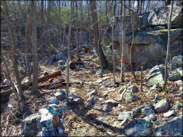
Photo Submitted 3/24/2013 (Thanks!)
Rocky Run Trail Photo
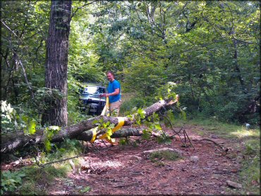
Photo Submitted 7/15/2012 (Thanks!)
Rocky Run Trail Photo
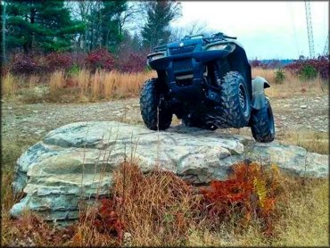
Photo Submitted 10/31/2014 (Thanks!)
Rocky Run Trail Photo
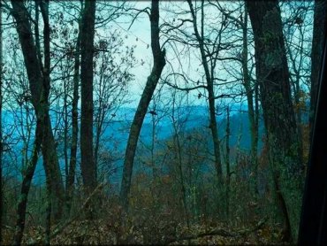
Photo Submitted 10/31/2014 (Thanks!)
Rocky Run Trail Photo
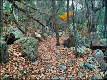
Photo Submitted 10/31/2014 (Thanks!)
Rocky Run Trail Photo
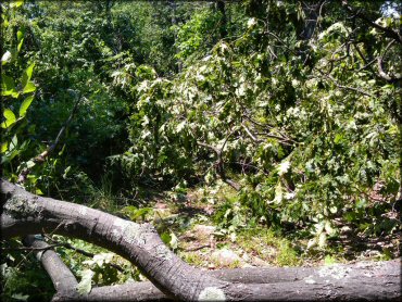
An example of some of the downed trees blocking the trail after a recent storm. Photo Submitted 6/30/2012 (Thanks!)
Rocky Run Trail Photo
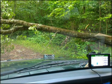
Photo Submitted 7/15/2012 (Thanks!)
RIDER COMMENTS & REVIEWS