 |
      |
| Home > Washington > Batey Bould |
Batey Bould Motorcycle Trails
Friday, August 8, 2025
| Other Names | Colville National Forest, Tacoma Peak Trail, Boulder Mountain Trail, Trimble Creek, Pend Oreille River, Little Pend Oreille ORV Trail System, LPO Trail System |
| Last Known Status | Open |
This part of the Colville National Forest offers over 40 miles of technical single track trails that wind through open meadows to mountain peaks. The terrain is rugged and has some steep climbs, loose chunk rock, narrow switchbacks and steep descents. The trails form long loops that eventually tie into the Little Pend Oreille Trail System.
The main staging area connects to the southern part of the trail system and has four campsites, each with a picnic table, fire pit and hand pump water spigots.
The area is generally open for riding between May through October but the trails may be accessible during winter months. Call before you haul.
REGULATIONS
| Permit Required | Yes | WA ORV Tab |
| Dates Open | Year-Round | |
| Other ATV Stickers Accepted | Unknown | |
| Spark Arrestor | Yes | A spark arresting exhaust silencer or end cap is required for all vehicles. |
| Noise Limit | ||
| Whip Flags | Not Required | |
| Maximum Vehicle Width | ||
 Motorcycles & Dirt Bikes Motorcycles & Dirt Bikes | Permitted | |
 ATVs ATVs | Prohibited | |
 UTV & SXS UTV & SXS | Prohibited | |
 4x4 & Jeeps (registered) 4x4 & Jeeps (registered) | Prohibited | |
| Dune Buggy & Sand Rail 4x4 (unregistered) | Prohibited | |
| 2 Stroke Engines | No Restriction | |
 Camping Camping | Some Areas | (camp in developed sites only) |
 Campfires Campfires | Some Areas | (permitted in developed campsites only) |
| Night Riding | Unknown | |
| Trail Blazing | Prohibited | keep vehicle on trail |
| Rule Enforcement |
TERRAIN
| Miles Of Trail | 40 | |
| Climate Type | Forest | |
| Elevation | 2500 to 4500 ft. | |
| Trail Maintenance | Marked, Not Rated, Lightly Maintained | |
| Loose Dirt |  Some Some | |
| Hard Pack |  Mostly Mostly | |
| Sand |  None None | |
| Mud |  Little Little | |
| Dust | Little | |
| Rocks | Little | |
| Trees |  All All | |
| Steep Hills |  Many Many | |
| Small Jumps | None | |
| Large Jumps | None | |
| Berms | Many | |
| Sand/Gravel Pits | None | |
| Single Track | All | |
| Roads | None | |
| Shade | Many | |
| Hazards |  Few Few | (hazards assumed marked but use caution) |
 Novice Novice | Little | |
 Amateur Amateur | Some | |
 Expert Expert | Mostly |
TYPE OF AREA
| Area | Motorized Trails |
| Land | National Forest |
GPS POINTS


KEY SERVICES
 Gasoline Gasoline | 5-20 Miles (SE) | Texaco (509) 445-1294 |
| Diesel | 5-20 Miles (SE) | Texaco (509) 445-1294 |
 Water Water | On Site | |
 RV Hookup RV Hookup | 20-30 Miles (SE) | Moonlight RV Park (509) 447-0631 |
 RV Disposal RV Disposal | 20-30 Miles (SE) | Moonlight RV Park (509) 447-0631 |
| Campground | On Site | |
 Conv Store Conv Store | 5-20 Miles (SE) | Texaco (509) 445-1294 |
FEES & PASSES
| Parking | (None) |
| Entry | (None) |
| Riding | (None) |
| Camping | (None) |
RATINGS
| Our Rating |  Very Good Very Good |
| Recommended Stay | 1-2 Days |
| Comments | (Scroll Down For Rider Reviews & Comments) |
DRIVING DIRECTIONS
| Nearest City | Cusick, WA | ||
| Address | Sicley Road, Cusick, WA 99119 | ||
| From: Newport, WA
1) Take SR-20 West about 20 miles 2) Turn left (west) onto Kirchan Road, continue 1.6 miles 3) Turn right (north) onto Calispell Road, continue about 1 mile 4) Turn left (west) onto Sicley Road, continue 1.5 miles 5) Staging area is on the left. |


OFFICIAL CONTACTS
| Contact Info | Colville National Forest 765 South Main Street Colville, WA 99114 (509) 684-7000 mailroom_r6_colville@fs.fed.us www.fs.usda.gov |
| Contact Info | Washington State Department of Licensing (360) 902-3770 titles@dol.wa.gov www.dol.wa.gov |
| Comment | WA ORV Tab Info |
Batey Bould Trail Photo
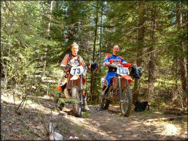
Photo Submitted 6/23/2015 (Thanks!)
Batey Bould Trail Photo
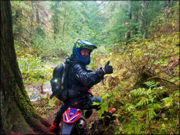
Photo Submitted 10/28/2017 (Thanks!)
Batey Bould Trail Photo
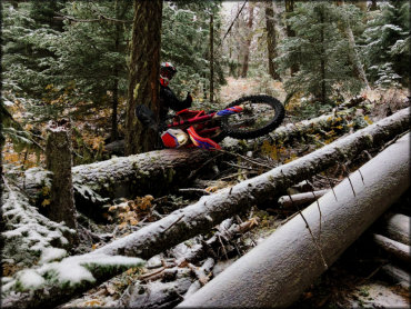
Photo Submitted 10/28/2017 (Thanks!)
Batey Bould Trail Photo
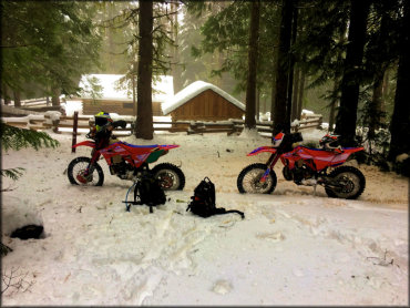
Photo Submitted 11/12/2017 (Thanks!)
Batey Bould Trail Photo
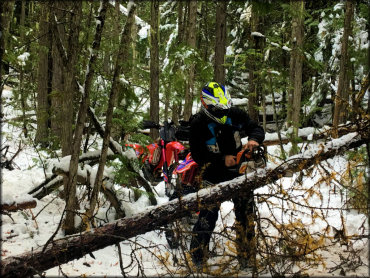
Photo Submitted 11/12/2017 (Thanks!)
Batey Bould Trail Photo
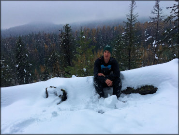
Photo Submitted 11/12/2017 (Thanks!)
Batey Bould Trail Photo
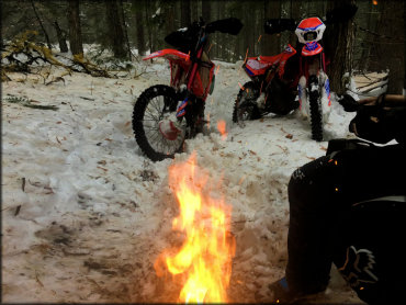
Photo Submitted 11/12/2017 (Thanks!)
RIDER COMMENTS & REVIEWS