 |
      |
| Home > Washington > Airway MX |
Airway MX Park
Saturday, May 10, 2025
| Other Names | Airway Heights, Spokane County ORV Park |
| Last Known Status | Open |
This motocross park offers several tracks that cater to all skill levels including a separate peewee track for beginners. The main track is surrounded by spectator bleachers which provide excellent views of the facility. All tracks are regularly groomed and watered.
The property has some modern amenties that include spacious day use parking, restroom / shower facilities and concession stands during race weekends. A campground is also available that has 60 sites, each with electric and water hookups.
The park is usually open for practice on Thursdays and weekends but hours may change if a race is being hosted or due to inclement weather so call first before heading out.
REGULATIONS
| Permit Required | No | |
| Dates Open | Thursday 2pm-8pm, Friday 10am-8pm, Weekends 10am-8pm | |
| Other ATV Stickers Accepted | Unknown | |
| Spark Arrestor | No | A spark arresting exhaust silencer or end cap is not required but is always recommended. |
| Noise Limit | No | |
| Whip Flags | Not Required | |
| Maximum Vehicle Width | ||
 Motorcycles & Dirt Bikes Motorcycles & Dirt Bikes | Permitted | |
 ATVs ATVs | Certain Times | permitted during harescramble events, check website for schedule |
 UTV & SXS UTV & SXS | Certain Times | permitted during harescramble events, check website for schedule |
 4x4 & Jeeps (registered) 4x4 & Jeeps (registered) | Prohibited | |
| Dune Buggy & Sand Rail 4x4 (unregistered) | Prohibited | |
| 2 Stroke Engines | No Restriction | |
| MX Helmet Required | Yes | |
 Camping Camping | Some Areas | (camp in developed sites only) |
 Campfires Campfires | Some Areas | (permitted in developed campsites only) |
| Night Riding | No | |
| Trail Blazing | Prohibited | |
| Rule Enforcement |
TYPE OF AREA
| Area | MX Track |
| Land | County Land |

| Features | Public |
| Max Engine Size | No Maximum |
| Min Engine Size | No Minimum |
| Features | Public |
| Max Engine Size | No Maximum |
| Min Engine Size | No Minimum |
| Features | Public |
| Max Engine Size | No Maximum |
| Min Engine Size | No Minimum |
FEES & PASSES
| Parking | (None) |
| Entry | (None) |
| Riding | Yes ($35.00 per rider) night practice - $40/rider, main and amature track - $35/rider, peewee track - $20/rider |
| Camping | Yes Tent: $10.00 RV: $25.00 Addtl. Vehicle: $0.00 |
RATINGS
| Our Rating |  Good Good |
| Recommended Stay | Full Day |
| Comments | (Scroll Down For Rider Reviews & Comments) |
DRIVING DIRECTIONS
| Nearest City | Spokane, WA | ||
| Address | 12402 Sprague Ave, Airway Heights, WA 99001 | ||
| From: Spokane, WA
1) Take I-90 West to Exit 277 2) Merge onto Hwy 2, continue about 6 miles 3) Turn right (north) onto Hayford Road, continue 1.9 miles 4) Turn left (west) onto Sprague Ave, continue about 1 mile toward park entrance. |


OFFICIAL CONTACTS
| Contact Info | Airway MX Park 12402 Sprague Ave Airway Heights, WA 99001 (509) 218-5366 (208) 446-9258 airwaymxp@gmail.com jtairway@gmail.com www.airwayx.com |
Airway MX Track Photo
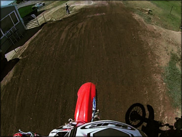
Photo Submitted 3/27/2017 (Thanks!)
Airway MX Track Photo
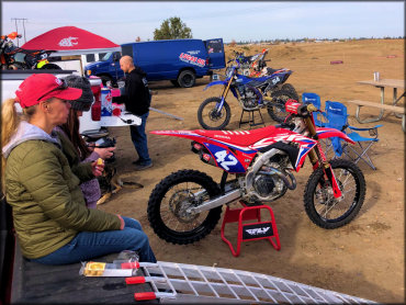
Photo Submitted 10/27/2021 (Thanks!)
ADD PHOTOS
TERRAIN
| Approx Size | 183 acres | |
| Climate Type | Urban/man-made | |
| Elevation | 2350 to 2375 ft. | |
| Loose Dirt |  All All | |
| Hard Pack |  None None | |
| Sand | None | |
| Mud | None | |
| Dust | None | |
| Rocks | None | |
| Trees |  Few Few | |
| Steep Hills | None | |
| Water Crossings | None | |
| Small Jumps |  Many Many | |
| Large Jumps |  Some Some | |
| Berms | All | |
| Sand/Gravel Pits | None | |
| Single Track | None | |
| Roads | None | |
| Shade | Few | |
| Ranges/Gunfire | None | |
| Hazards | Few | (hazards assumed marked but use caution) |
 Novice Novice | Some | |
 Amateur Amateur |  Mostly Mostly | |
 Expert Expert |  Little Little |
GPS POINTS


KEY SERVICES
 Gasoline Gasoline | 1-5 Miles (E) | Chevron (509) 481-2130 |
| Diesel | 1-5 Miles (E) | Chevron (509) 481-2130 |
 Water Water | On Site | |
 RV Hookup RV Hookup | On Site | |
 RV Disposal RV Disposal | On Site | |
| Campground | On Site | |
 Conv Store Conv Store | 1-5 Miles (E) | Chevron (509) 481-2130 |
RIDER COMMENTS & REVIEWS