 |
      |
| Home > Washington > Miller Peak |
Miller Peak
Saturday, May 10, 2025
| Other Names | Okanogan-wenatchee National Forest, Wenatchee River Ranger District, Naches, Taneum, Teanaway Ridge, Iron Bear, Miller Creek, Stafford Creek, Bear Creek, Red Top Mountain, Indian Creek |
| Last Known Status | Open |
This part of the Okanogan–Wenatchee National Forest offers three challenging single track trails that are open to motorcycles only. Due to the lack of easy trails and rough terrain that consists of steep climbs and narrow switchbacks, this trail system should only be attempted by experienced riders.
This trail system has two staging areas but space is limited so large trailers or RVs are not recommended. Note that there is currently no self pay station at either staging area so visitors must obtain a recreation pass prior to entering.
REGULATIONS
| Permit Required | Yes | WA ORV Tab |
| Dates Open | June 15 - April 15 | |
| Other ATV Stickers Accepted | Unknown | |
| Spark Arrestor | Yes | A spark arresting exhaust silencer or end cap is required for all vehicles. |
| Noise Limit | Yes (105 dB) | |
| Whip Flags | Not Required | |
| Maximum Vehicle Width | ||
 Motorcycles & Dirt Bikes Motorcycles & Dirt Bikes | Permitted | |
 ATVs ATVs | Prohibited | |
 UTV & SXS UTV & SXS | Prohibited | |
 4x4 & Jeeps (registered) 4x4 & Jeeps (registered) | Prohibited | |
| Dune Buggy & Sand Rail 4x4 (unregistered) | Prohibited | |
| 2 Stroke Engines | No Restriction | |
| MX Helmet Required | Yes | |
 Camping Camping | Some Areas | (camp in developed sites only) |
 Campfires Campfires | Some Areas | (permitted in developed campsites only) |
| Night Riding | Unknown | Not Recommended |
| Trail Blazing | Prohibited | keep on the trail |
| Rule Enforcement |
TERRAIN
| Miles Of Trail | 30 | |
| Climate Type | Forest | |
| Elevation | 3200 to 6300 ft. | |
| Trail Maintenance | Marked, Not Rated, Lightly Maintained | |
| Loose Dirt |  Some Some | |
| Hard Pack | Some | |
| Sand |  None None | |
| Mud |  Little Little | |
| Dust | Some | |
| Rocks | Some | |
| Trees |  All All | |
| Steep Hills |  Many Many | |
| Water Crossings | Some | |
| Small Jumps | None | |
| Large Jumps | None | |
| Berms | Some | |
| Sand/Gravel Pits | None | |
| Single Track | All | |
| Roads | None | |
| Shade | Many | |
| Hazards |  Few Few | (hazards assumed marked but use caution) Beware of cliffs. |
 Novice Novice | None | |
 Amateur Amateur | Some | |
 Expert Expert |  Mostly Mostly |
TYPE OF AREA
| Area | Motorized Trails |
| Land | National Forest |
GPS POINTS


KEY SERVICES
 Gasoline Gasoline | 20-30 Miles (SW) | 76 (509) 674-1176 |
| Diesel | 20-30 Miles (SW) | 76 (509) 674-1176 |
 Water Water | 30+ Miles (SE) | Ellensburg KOA (509) 925-9319 |
 RV Hookup RV Hookup | 30+ Miles (SE) | Ellensburg KOA (509) 925-9319 |
 RV Disposal RV Disposal | 30+ Miles (SE) | Ellensburg KOA (509) 925-9319 |
| Campground | 1-5 Miles (W) | Twentynine Pines Campground (509) 925-8510 |
 Conv Store Conv Store | 20-30 Miles (SW) | 76 (509) 674-1176 |
FEES & PASSES
| Parking | Yes ($5.00) Recreation Pass Fee |
| Entry | (None) |
| Riding | (None) |
| Camping | (None) |
| Comment | No self pay station available - visitors must obtain recreation pass prior to entering. |
RATINGS
| Our Rating |  Good Good |
| Recommended Stay | Full Day |
| Comments | (Scroll Down For Rider Reviews & Comments) |
DRIVING DIRECTIONS
| Nearest City | Cle Elum, WA | ||
| From: Seattle, WA
1) Take I-90 East to Exit 85 2) Turn left (north) off the exit ramp onto WA-10/WA-970, continue .2 miles 3) Turn right (east) to stay on WA-10/WA-970, continue 6.5 miles. 4) Turn left (north) onto Teanaway Road, continue 13 miles. 5) Veer right (north-east) onto Forest Road 9737, continue 2 miles 6) Veer right onto Forest Road 9703, continue about 1 mile towards staging area. |


OFFICIAL CONTACTS
| Contact Info | Okanogan–wenatchee National Forest 215 Melody Lane Wenatchee, WA 98801 (509) 664-9200 mailroom_r6_okanogan@fs.fed.us mailroom_r6_wenatchee@fs.fed.us www.fs.usda.gov |
| Contact Info | Washington State Department of Licensing (360) 902-3770 titles@dol.wa.gov www.dol.wa.gov |
Miller Peak Trail Photo
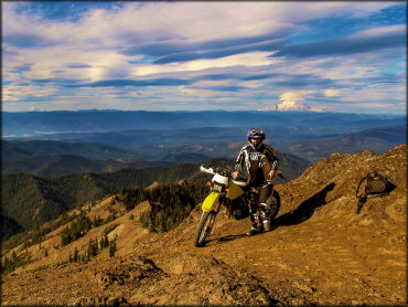
Photo Submitted 5/17/2021 (Thanks!)
Miller Peak Trail Photo
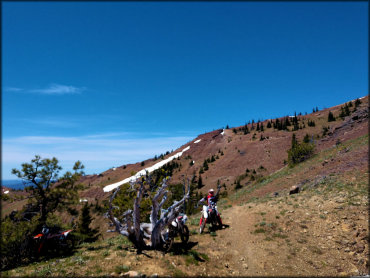
Photo Submitted 5/27/2018 (Thanks!)
Miller Peak Trail Photo
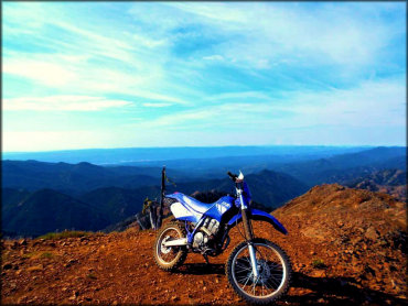
Photo Submitted 4/1/2018 (Thanks!)
Miller Peak Trail Photo
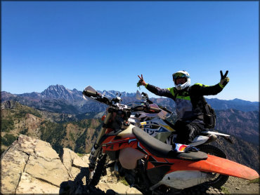
Photo Submitted 2/4/2023 (Thanks!)
RIDER COMMENTS & REVIEWS