 |
      |
| Home > Wyoming > Mosquito Creek |
Mosquito Creek
Sunday, May 31, 2026
| Other Names | Bridger-teton National Forest, Jackson Ranger District, Swinging Bridge, Cottonwood Creek, Mill Creek, Teton Pass, Taylor Creek |
| Last Known Status | Open |
This part of the Bridger-Teton National Forest offers around 12 miles of pure single track. The location is a bit remote and there is no designated staging area, so parking is limited. The trails can easily be covered in a couple hours but there are still several forest service roads to explore, making this a good place to bring a dual sport motorcycle.
The area is very scenic but has a short season (June through November). During wet weather the main entrance road can be very difficult to drive on and should be avoided.
Please note that these trails are only open to dirt bikes, hiking, mountain biking and equestrian use. Those looking for ATV trails should try North Shadow Mountain, Slate Creek/Dry Dallas or Murphy Squaw ATV Trail.
REGULATIONS
| Permit Required | Yes | WY ORV Permit |
| Dates Open | June 1 - November 30 | |
| Other ATV Stickers Accepted | No | All non-residents must purchase a Wyoming ORV permit. |
| Spark Arrestor | Yes | A spark arresting exhaust silencer or end cap is required for all vehicles. |
| Noise Limit | Yes (96 dB) | |
| Whip Flags | Not Required | |
| Maximum Vehicle Width | ||
 Motorcycles & Dirt Bikes Motorcycles & Dirt Bikes | Permitted | |
 ATVs ATVs | Prohibited | |
 UTV & SXS UTV & SXS | Prohibited | |
 4x4 & Jeeps (registered) 4x4 & Jeeps (registered) | Prohibited | |
| Dune Buggy & Sand Rail 4x4 (unregistered) | Prohibited | |
| 2 Stroke Engines | No Restriction | |
| MX Helmet Required | Yes | |
 Camping Camping | Some Areas | (camp in developed sites only) |
 Campfires Campfires | Some Areas | (permitted in developed campsites only) |
| Night Riding | Unknown | Not Recommended |
| Trail Blazing | Prohibited | keep vehicle on trail |
| Rule Enforcement |
TYPE OF AREA
| Area | Motorized Trails |
| Land | National Forest |
FEES & PASSES
| Parking | (None) |
| Entry | (None) |
| Riding | (None) |
| Camping | (None) |
RATINGS
| Our Rating |  Good Good |
| Recommended Stay | Half Day |
| Comments | (Scroll Down For Rider Reviews & Comments) |
DRIVING DIRECTIONS
| Nearest City | Wilson, WY | ||
| Address | Mosquito Creek Road, Jackson, WY 83001 | ||
| From: Wilson, WY
1) Take Fall Creek Road south 4.6 miles 2) Turn right (west) onto FS Road 30980/Mosquito Creek Road, continue 2.6 miles 3) Trailhead is on the left (south). |


OFFICIAL CONTACTS
| Contact Info | Bridger - Teton National Forest - Jackson Ranger District 25 Rosencrans Lane Jackson, WY 83001 (307) 739-5400 r4_b-t_info@fs.fed.us www.fs.usda.gov |
| Contact Info | Wyoming Department of State Parks 2301 Central Avenue Cheyenne, WY 82002 (877) 996-7275 (307) 777-6323 state.parks.parks@wyo.gov wyoparks.wyo.gov |
Mosquito Creek Trail Photo
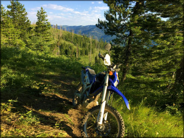
Photo Submitted 11/7/2018 (Thanks!)
Mosquito Creek Trail Photo
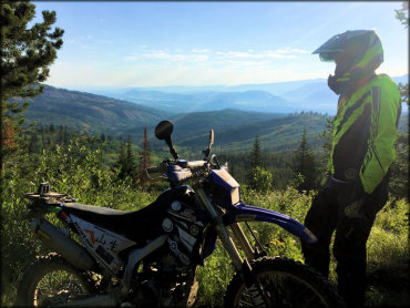
Photo Submitted 11/7/2018 (Thanks!)
Mosquito Creek Trail Photo
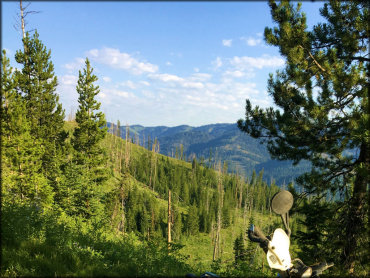
Photo Submitted 11/7/2018 (Thanks!)
ADD PHOTOS
TERRAIN
| Miles Of Trail | 12 | |
| Climate Type | Forest | |
| Elevation | 6400 to 6800 ft. | |
| Trail Maintenance | Marked, Not Rated, Lightly Maintained | |
| Loose Dirt |  Little Little | |
| Hard Pack |  Mostly Mostly | |
| Sand |  None None | |
| Mud | Little | |
| Dust | Little | |
| Rocks | Little | |
| Trees |  All All | |
| Steep Hills |  Few Few | |
| Water Crossings | Few | |
| Small Jumps | None | |
| Large Jumps | None | |
| Berms |  Many Many | |
| Sand/Gravel Pits | None | |
| Single Track | All | |
| Roads | Few | |
| Shade | All | |
| Hazards | Few | (hazards assumed marked but use caution) |
 Novice Novice | Little | |
 Amateur Amateur | Mostly | |
 Expert Expert |  Some Some |


KEY SERVICES
 Gasoline Gasoline | 5-20 Miles (N) | Exxon (307) 733-3314 |
| Diesel | 5-20 Miles (N) | Exxon (307) 733-3314 |
 Water Water | 5-20 Miles (N) | Jackson Hole Campground (307) 732-2267 |
 RV Hookup RV Hookup | 5-20 Miles (N) | Jackson Hole Campground (307) 732-2267 |
 RV Disposal RV Disposal | 5-20 Miles (N) | Jackson Hole Campground (307) 732-2267 |
| Campground | 5-20 Miles (S) | East Table Creek Campground (307) 739-5400 |
 Conv Store Conv Store | 5-20 Miles (N) | Exxon (307) 733-3314 |
RIDER COMMENTS & REVIEWS