 |
      |
| Home > Alaska > Pinochle Creek Trail |
Pinochle Creek Trail
Saturday, May 10, 2025
| Other Names | Hicks Creek Trail, Knik-nelchina Trail, Purinton Creek, Eureka Trails, Belanger Pass, Chickaloon-Knik-Nelchina |
| Last Known Status | Open |
The Pinochle Creek Trail is about 16 miles long and starts off north of the Glenn Highway and follows Hicks Creek. The terrain is mostly easy but can be very difficult during wet weather or summer months which can create large mud bogs and deep water crossings that require a winch.
The Pinochle Trail Campground is located right across the main trailhead and offers easy access. The campground opened to the public during the summer of 2020 and currently has no hookups but offers seven sites with picnic tables and BBQ grills, one cabin rental with electricity (bring your own blankets, pillows and drinking water) plus plenty of room to park.
The trail is open year-round and during the winter months snowmobiles are permitted. The trail also ties into the nearby Eureka and Puritan areas.
REGULATIONS
| Permit Required | ||
| Dates Open | Year-Round | |
| Other ATV Stickers Accepted | Unknown | |
| Spark Arrestor | Yes | A spark arresting exhaust silencer or end cap is required for all vehicles. |
| Noise Limit | ||
| Whip Flags | Not Required | |
| Maximum Vehicle Width | No Restriction | |
 Motorcycles & Dirt Bikes Motorcycles & Dirt Bikes | Permitted | |
 Four Wheelers Four Wheelers | Permitted | |
 UTV & SXS UTV & SXS | Permitted | |
 4x4 & Jeeps (registered) 4x4 & Jeeps (registered) | Permitted | |
| Dune Buggy & Sand Rail 4x4 (unregistered) | Permitted | |
| 2 Stroke Engines | No Restriction | |
 Camping Camping | Some Areas | (camp in developed sites only) |
 Campfires Campfires | ||
| Night Riding | Unknown | |
| Trail Blazing | Prohibited | stay on trail |
| Rule Enforcement |
TERRAIN
| Miles Of Trail | 16 | |
| Climate Type | Forest | |
| Elevation | 1780 to 3348 ft. | |
| Trail Maintenance | Unknown | |
| Loose Dirt |  Little Little | |
| Hard Pack |  Some Some | |
| Sand | Little | |
| Mud |  Mostly Mostly | |
| Dust | Some | |
| Rocks | Some | |
| Trees | Some | |
| Steep Hills |  Many Many | |
| Water Crossings | Some | |
| Small Jumps |  None None | |
| Large Jumps | None | |
| Berms | None | |
| Sand/Gravel Pits | None | |
| Single Track | None | |
| Roads | Some | |
| Shade | Some | |
| Hazards |  Few Few | (hazards assumed marked but use caution) |
 Novice Novice | Some | |
 Amateur Amateur | Mostly | |
 Expert Expert | Little |
TYPE OF AREA
| Area | Motorized Trails |
| Land | DNR, Private |
GPS POINTS


KEY SERVICES
 Gasoline Gasoline | 5-20 Miles (W) | Tesoro (907) 746-6706 |
| Diesel | 30+ Miles (SW) | Fred Meyer Fuel Center (907) 746-4244 |
 Water Water | 1-5 Miles (E) | Grand View Cafe and RV Park (907) 746-4480 |
 RV Hookup RV Hookup | 1-5 Miles (E) | Grand View Cafe and RV Park (907) 746-4480 |
 RV Disposal RV Disposal | 1-5 Miles (E) | Grand View Cafe and RV Park (907) 746-4480 |
| Campground | On Site | Pinochle Trail Campground (907) 707-6228 |
 Conv Store Conv Store | 5-20 Miles (W) | Tesoro (907) 746-6706 |
FEES & PASSES
| Parking | (None) |
| Entry | (None) |
| Riding | (None) |
| Camping | Yes Tent: $20.00 RV: $20.00 Addtl. Vehicle: $0.00 Pinochle Trail Campground Fee |
RATINGS
| Our Rating |  Good Good |
| Recommended Stay | 1-2 Days |
| Comments | (Scroll Down For Rider Reviews & Comments) |
DRIVING DIRECTIONS
| Nearest City | Glacier View, AK | ||
| Address | Pinochle Lane, Glacier View, AK 99674 | ||
| From: Anchorage, AK
1) AK-1/Glenn Highway North about 90 miles 2) Pinochle Trail Campground is on the right (south). |


OFFICIAL CONTACTS
| Contact Info | Alaska DNR - Southcentral Regional Office 550 West 7th Avenue Anchorage, AK 99501 (907) 269-8564 kyle.kidder@alaska.gov aws.state.ak.us |
| Contact Info | Pinochle Trail Campground Pinochle Lane Glacier View, AK 99674 (907) 707-6228 info@pinochlecamp.com www.pinochletrail.com |
| Comment | call or text for rates and availability |
Pinochle Creek Trail Photo
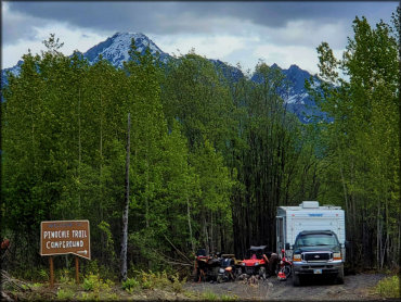
This is the main entrance for Pinochle Trail Campground. Photo Submitted 6/17/2020 (Thanks!)
Pinochle Creek Trail Photo
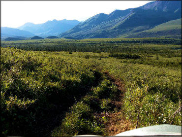
Another view of the Pinochle Trail. There is plenty of panoramic views to be seen from here. Photo Submitted 6/17/2020 (Thanks!)
Pinochle Creek Trail Photo
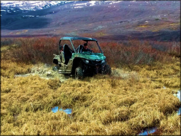
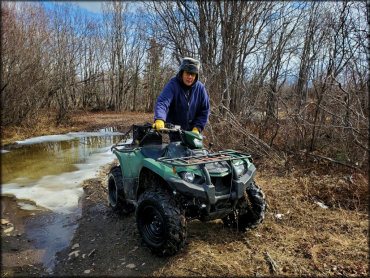
Some sections of the trail can get waterlogged. Bring a winch. Photo Submitted 6/17/2020 (Thanks!)
Pinochle Creek Trail Photo
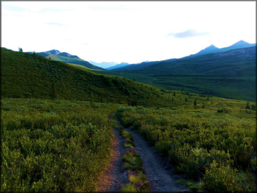
This is a view of the Pinochle Trail. This section is hard packed but during wet weather can be very muddy. Photo Submitted 6/17/2020 (Thanks!)
Pinochle Creek Trail Photo
The Pinochle Trail is open year-round. During the winter months snowmobiles are permitted. Photo Submitted 6/17/2020 (Thanks!)
Pinochle Creek Trail Photo
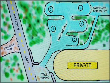
This is a map of Pinochle Trail Campground. Photo Submitted 6/17/2020 (Thanks!)
Pinochle Creek Trail Photo
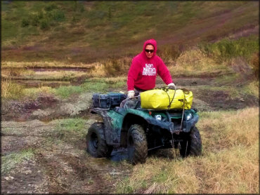
Photo Submitted 6/17/2020 (Thanks!)
RIDER COMMENTS & REVIEWS