 |
      |
| Home > Arizona > Camp Verde Trails |
Camp Verde Trails
Wednesday, August 13, 2025
| Other Names | Prescott National Forest, Verde Ranger District, Copper Canyon Trailhead, Ryal Canyon Trail, Tomkins Trail, Box T Trail, Grassy Mountain, Squaw Peak, Bald Hill, Verde River, Hayfield Draw |
| Last Known Status | Open |
This part of the Prescott National Forest offers a large trail system offer miles of marked trails that eventually ties into the Hayfield Draw OHV Area to the north.
The Forest Service recently added a new trailhead which has a loading ramp, picnic tables, shade ramadas and a vault toilet. There is a small fee charged for parking but the area is open for day use only.
Most of the trails are rated as moderately challenging and are popular with ATVs and UTVs except for Trail #513 which is very rocky, steep and narrow.
The area is open year-round but the best time to visit is during the winter and spring months.
REGULATIONS
| Permit Required | Yes | AZGFD sticker required |
| Dates Open | Year-Round | |
| Other ATV Stickers Accepted | No | All non-residents must purchase an Arizona OHV decal. |
| Spark Arrestor | Yes | A spark arresting exhaust silencer or end cap is required for all vehicles. |
| Noise Limit | Yes (96 dB) | |
| Whip Flags | Not Required | |
| Maximum Vehicle Width | Yes (50 inches) | has entrance gate or posts |
 Motorcycles & Dirt Bikes Motorcycles & Dirt Bikes | Permitted | |
 ATVs ATVs | Permitted | (maximum width 50 inches) |
 UTV & SXS UTV & SXS | Permitted | (maximum width 50 inches) |
 SUVs & Jeeps (registered) SUVs & Jeeps (registered) | Prohibited | |
| Dune Buggy & Sand Rail 4x4 (unregistered) | Prohibited | |
| 2 Stroke Engines | No Restriction | |
| MX Helmet Required | Youth Only | required for persons under 18 by state law (RiderPlanet strongly recommends helmets for all riders.) |
 Camping Camping | Prohibited | |
 Campfires Campfires | Prohibited | |
| Night Riding | No | riding permitted during daylight hours only |
| Trail Blazing | Prohibited | keep vehicle on trail |
| Rule Enforcement | ||
| Comment | Camping is not permitted at the trailhead but dispersed camping is allowed alongside designated roads. | |
TYPE OF AREA
| Area | Motorized Trails |
| Land | National Forest |
FEES & PASSES
| Parking | (None) |
| Entry | Yes ($5.00 per vehicle) |
| Riding | (None) |
| Camping | (None) |
RATINGS
| Our Rating |  Good Good |
| Recommended Stay | Full Day |
| Comments | (Scroll Down For Rider Reviews & Comments) |
DRIVING DIRECTIONS
| Nearest City | Camp Verde, AZ | ||
| From: Flagstaff, AZ
1) Take I-17 South to Exit 287 2) Turn left (south) off the exit ramp onto AZ-260/Finnie Flat Road, continue 1.8 miles 3) Turn right (south) onto Oasis Road, continue .4 miles 4) Turn right (west) onto FS-136, continue about 2.5 miles 5) Staging area is on the right (north). |


OFFICIAL CONTACTS
| Contact Info | Prescott National Forest - Verde Ranger District 300 East Highway 260 Camp Verde, AZ 86322 (928) 567-4121 mailroom_r3_prescott@fs.fed.us www.fs.usda.gov |
Camp Verde Trails Photo
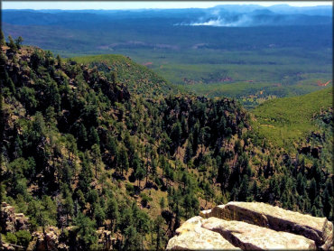
Photo Submitted 9/24/2015 (Thanks!)
Camp Verde Trails Photo
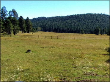
Photo Submitted 9/24/2015 (Thanks!)
ADD PHOTOS
TERRAIN
| Miles Of Trail | 50 | |
| Climate Type | Desert | |
| Elevation | 3200 to 3600 ft. | |
| Trail Maintenance | Marked, Not Rated, Lightly Maintained | |
| Loose Dirt |  Little Little | |
| Hard Pack |  Mostly Mostly | |
| Sand | Little | |
| Mud | Little | |
| Dust |  Some Some | |
| Rocks | Mostly | Trail #513 is very rocky |
| Trees |  Few Few | |
| Steep Hills | Some | |
| Water Crossings | Few | |
| Small Jumps |  None None | |
| Large Jumps | None | |
| Berms | Few | |
| Sand/Gravel Pits | None | |
| Single Track | Some | |
| Roads | Some | |
| Intersections | Some | |
| Shade | Few | |
| Hazards | Few | (hazards assumed marked but use caution) |
 Novice Novice | Some | |
 Amateur Amateur | Mostly | |
 Expert Expert | Little |


KEY SERVICES
 Gasoline Gasoline | 1-5 Miles (N) | Shell (928) 567-3886 |
| Diesel | 1-5 Miles (N) | Shell (928) 567-3886 |
 Water Water | 1-5 Miles (NE) | Trails End RV Park (928) 567-0100 |
 RV Hookup RV Hookup | 1-5 Miles (NE) | Trails End RV Park (928) 567-0100 |
 RV Disposal RV Disposal | 1-5 Miles (NE) | Trails End RV Park (928) 567-0100 |
| Campground | 20-30 Miles (N) | Dead Horse Ranch Campground (928) 634-5283 |
 Conv Store Conv Store | 1-5 Miles (N) | Shell (928) 567-3886 |
RIDER COMMENTS & REVIEWS