 |
      |
| Home > California > Divide Peak |
Divide Peak OHV Route
Monday, July 28, 2025
| Other Names | Santa Ynez Valley, Rafael Mountains, Los Padres National Forest, San Ysidro Creek, Romero Canyon Creek, Santa Barbara Ranger District, 5N12.1, 26W21 |
| Last Known Status | Open |
This part of the Los Padres National Forest offers around 12 miles of trails that provide excellent views of Santa Barbara, Pacific Ocean, Channel Islands and surrounding mountains. The trail system mainly consists of rocky fire roads with some steep technical sections, a few designated single track motorcycle trails and a natural terrain motocross track.
ATVs are not permitted on the single track trails (located near the mx track), and while they are allowed on the main trail (5N12.1), four wheelers are not recommended due to the rugged and narrow terrain. Beginners, ATV and UTV riders are advised to check out nearby Camuesa/Upper Osso Area which has wider and easier trails.
Dispersed camping is permitted throughout the forest but there are some designated campgrounds nearby (Adventure Pass required). Note that there is no direct trail access from the campgrounds, so unless street legal you will have to haul your bike to and from the staging area.
The trailhead is located about 20 miles east from the turnoff for Hwy 154 and East Camino Cielo, which is usually closed before, during and after a storm, so check with the Santa Barbara Ranger District before heading out.
REGULATIONS
| Permit Required | Yes | CA OHMVR stickers required |
| Dates Open | Year-Round | CA OHMVR red sticker vehicles permitted from Oct 1 to April 30 |
| Other ATV Stickers Accepted | Yes | Residents of any state not listed must purchase a Nonresident OHV Use Permit. (AR, AZ, CA, CO, CT, DE, IA, ID, IN, LA, MA, MD, ME, MI, MN, MO, MT, ND, NH, NJ, NM, NV, NY, OH, OK, OR, PA, RI, TX, UT, VT, WA, WI, WY) |
| Spark Arrestor | Yes | A spark arresting exhaust silencer or end cap is required for all vehicles. |
| Noise Limit | Yes (96 dB) | CA OHMVR noise limits apply (1985/older limit 101 dB, 1986/newer limit 96 dB) |
| Whip Flags | Not Required | |
| Maximum Vehicle Width | Yes (50 inches) | has entrance gate and narrow terrain |
 Motorcycles & Dirt Bikes Motorcycles & Dirt Bikes | Permitted | CA OHMVR stickers required |
 ATVs ATVs | Some Areas | Not Recommended CA OHMVR stickers required (maximum width 50 inches) permitted on Trail 5N12.1 |
 UTV & SXS UTV & SXS | Prohibited | CA OHMVR stickers required |
 SUVs & Jeeps (registered) SUVs & Jeeps (registered) | Prohibited | |
| Dune Buggy & Sand Rail 4x4 (unregistered) | Prohibited | CA OHMVR stickers required |
| 2 Stroke Engines | Certain Times | CA OHMVR restrictions apply |
| MX Helmet Required | Yes | helmets required by state law |
 Camping Camping | ||
 Campfires Campfires | ||
| Night Riding | Unknown | Not Recommended |
| Trail Blazing | Prohibited | keep on the trail |
| Rule Enforcement |
TERRAIN
| Approx Size | 6,400 acres (10 sq mi) | |
| Miles Of Trail | 12 | |
| Climate Type | Forest | |
| Elevation | 2500 to 3000 ft. | |
| Trail Maintenance | Marked, Not Rated, Lightly Maintained | |
| Loose Dirt |  Little Little | |
| Hard Pack |  Mostly Mostly | |
| Sand |  None None | |
| Mud | Little | |
| Dust | Little | |
| Rocks |  Some Some | |
| Trees |  Few Few | |
| Steep Hills | Some | |
| Water Crossings | None | |
| Small Jumps | Few | |
| Large Jumps | None | |
| Berms | Some | |
| Sand/Gravel Pits | None | |
| Single Track | Some | |
| Roads | Few | |
| Shade | Few | |
| Hazards | Few | (hazards assumed marked but use caution) |
 Novice Novice | None | |
 Amateur Amateur | Little | |
 Expert Expert | Mostly |
TYPE OF AREA
| Area | Motorized Trails, MX Track |
| Land | National Forest |

| Features | Public |
| Max Engine Size | No Maximum |
| Min Engine Size | No Minimum |
GPS POINTS


KEY SERVICES
 Gasoline Gasoline | 1-5 Miles (S) | Chevron (805) 969-2594 |
| Diesel | 1-5 Miles (S) | Chevron (805) 969-5845 |
 Water Water | 20-30 Miles (SW) | Ocean Mesa RV and Campground (866) 410-5783 |
 RV Hookup RV Hookup | 20-30 Miles (SW) | Ocean Mesa RV and Campground (866) 410-5783 |
 RV Disposal RV Disposal | 20-30 Miles (SW) | Ocean Mesa RV and Campground (866) 410-5783 |
| Campground | 1-5 Miles (N) | Middle Santa Ynez Campground (805) 967-3481 |
 Conv Store Conv Store | 5-20 Miles (S) | Montecito Village Grocery (805) 969-1112 |
FEES & PASSES
| Parking | Yes ($5.00) Adventure Pass Fee - $5/day or $30/year |
| Entry | (None) |
| Riding | (None) |
| Camping | Yes Tent: $5.00 RV: $5.00 Addtl. Vehicle: $0.00 Middle Santa Ynez Campground Fee (Adventure Pass Required) |
RATINGS
| Our Rating |  Good Good |
| Recommended Stay | Full Day |
| Comments | (Scroll Down For Rider Reviews & Comments) |
DRIVING DIRECTIONS
| Nearest City | Santa Barbara, CA | ||
| Address | Camuesa Road, Carpinteria, CA 93013 | ||
| From: Santa Barbara, CA
1) Take Hwy 154 North about 8 miles 2) Turn right (east) onto East Camino Cielo, continue about 18 miles 3) Continue straight onto dirt road (road name changes to Camuesa Road), continue 1.3 miles 4) Staging area is on the left (north). |


OFFICIAL CONTACTS
| Contact Info | Los Padres National Forest - Santa Barbara Ranger District 3505 Paradise Road Santa Barbara, CA 93105 (805) 967-3481 mailroom_r5_los_padres@fs.fed.us www.fs.usda.gov |
Divide Peak OHV Area Photo
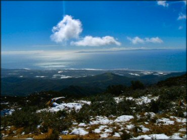
Views of the Pacific Ocean at the top of the ridge. Photo Submitted 1/20/2012 (Thanks!)
Divide Peak OHV Area Photo
Most of the trails are hard packed with scattered loose rocks. Photo Submitted 7/21/2013 (Thanks!)
Divide Peak OHV Area Photo
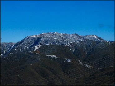
The trails provide nice views of the San Rafael Mountains. Photo Submitted 1/20/2012 (Thanks!)
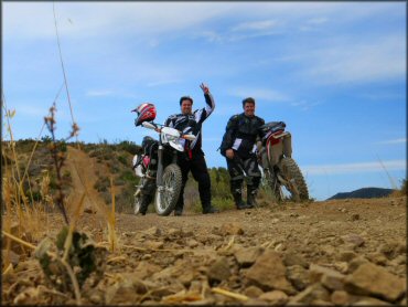
Divide Peak OHV Area Photo
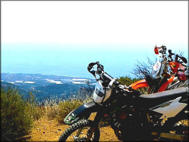
Photo Submitted 7/29/2016 (Thanks!)
Divide Peak OHV Area Photo
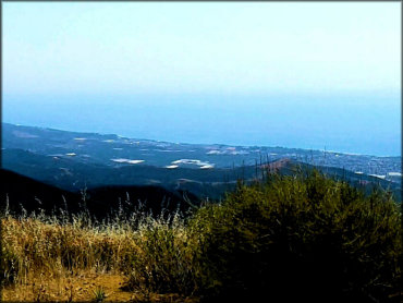
Photo Submitted 7/29/2016 (Thanks!)
Divide Peak OHV Area Photo
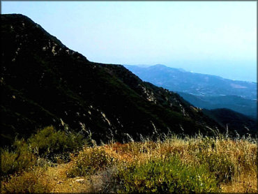
Photo Submitted 7/29/2016 (Thanks!)
RIDER COMMENTS & REVIEWS