 |
      |
| Home > Idaho > Greenhorn |
Greenhorn
Thursday, April 30, 2026
| Other Names | Sawtooth National Forest, Ketchum Ranger District, Greenhorn Creek, Mahoney Butte, Poison Flat, Warfield Creek |
| Last Known Status | Open |
Located a short distance south of Sun Valley, Idaho, this part of the Sawtooth National Forest features miles of pure single track trails that form multiple loops and wind through grassy meadows, pine and aspen trees.
The trails are mostly smooth with some loose chunk rock and occasional tree roots with light to moderate elevation changes. Dirt bike riders should note that this area is popular with mountain bikes and hikers, so use caution.
The staging area offers plenty of room for parking and while there is no fee charged to park or ride, an Idaho OHV Registration Sticker is required for all dirt bikes. For current conditions contact the Ketchum Ranger District.
REGULATIONS
| Permit Required | Yes | Idaho OHV Registration Sticker |
| Dates Open | May 1 through November 30 | |
| Other ATV Stickers Accepted | No | A non-resident registration sticker must be purchased. (As of January 2020, Idaho no longer honors stickers from other states.) |
| Spark Arrestor | Yes | A spark arresting exhaust silencer or end cap is required for all vehicles. |
| Noise Limit | Yes (96 dB) | |
| Whip Flags | Not Required | |
| Maximum Vehicle Width | ||
 Motorcycles & Dirt Bikes Motorcycles & Dirt Bikes | Permitted | |
 ATVs ATVs | Prohibited | |
 UTV & SXS UTV & SXS | Prohibited | |
 4x4 & Jeeps (registered) 4x4 & Jeeps (registered) | Prohibited | |
| Dune Buggy & Sand Rail 4x4 (unregistered) | Prohibited | |
| 2 Stroke Engines | No Restriction | |
| MX Helmet Required | Youth Only | youth only required for persons under 18 by state law (RiderPlanet strongly recommends helmets for all riders.) |
 Camping Camping | Some Areas | (camp in developed sites only) |
 Campfires Campfires | ||
| Night Riding | Unknown | |
| Trail Blazing | Prohibited | stay on trail |
| Rule Enforcement |
TERRAIN
| Miles Of Trail | 50 | |
| Climate Type | Forest | |
| Elevation | 5875 to 8400 ft. | |
| Trail Maintenance | Marked, Not Rated, Lightly Maintained | |
| Loose Dirt |  Little Little | |
| Hard Pack |  Mostly Mostly | |
| Sand |  None None | |
| Mud | Little | |
| Dust | Little | |
| Rocks | Little | |
| Trees |  Many Many | |
| Steep Hills | Many | |
| Water Crossings |  Few Few | |
| Small Jumps | None | |
| Large Jumps | None | |
| Berms | Many | |
| Sand/Gravel Pits | None | |
| Single Track |  All All | |
| Roads | Few | |
| Intersections |  Some Some | |
| Rider Traffic | Few | |
| Shade | Many | |
| Hazards | Few | (hazards assumed marked but use caution) |
 Novice Novice | Little | |
 Amateur Amateur | Mostly | |
 Expert Expert | Some |
TYPE OF AREA
| Area | Motorized Trails |
| Land | National Forest |


KEY SERVICES
 Gasoline Gasoline | Hailey, ID | |
| Diesel | Hailey, ID | |
 Water Water | Hailey, ID | |
 RV Hookup RV Hookup | Hailey, ID | |
 RV Disposal RV Disposal | Hailey, ID | |
| Campground | Hailey, ID | |
 Conv Store Conv Store | Hailey, ID |
FEES & PASSES
| Parking | (None) |
| Entry | (None) |
| Riding | (None) |
| Camping | (None) |
RATINGS
| Our Rating |  Very Good Very Good |
| Recommended Stay | 1-2 Days |
| Comments | (Scroll Down For Rider Reviews & Comments) |
DRIVING DIRECTIONS
| Nearest City | Hailey, ID | ||
| Address | Greenhorn Gulch, Hailey, ID 83333 | ||
| From: Twin Falls, ID
1) Take Hwy 93 North about 25 miles 2) Continue straight (north) onto Hwy 75, continue about 48 miles 3) Turn left (west) onto Greenhorn Gulch Road, continue 3.6 miles toward staging area. |

OFFICIAL CONTACTS
| Contact Info | Sawtooth National Forest - Ketchum Ranger District 206 Sun Valley Road Sun Valley, ID 83353 (208) 622-5371 mailroom_r4_sawtooth@fs.fed.us www.fs.usda.gov |
| Contact Info | Idaho Parks And Recreation 5657 E. Warm Springs Ave Boise, ID 83716 (208) 334-4197 reghelpline@idpr.idaho.gov idahostateparks.reserveamerica.com |
| Comment | Idaho OHV Sticker Info |
Greenhorn Trail Photo
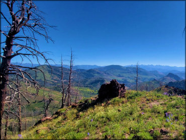
Photo Submitted 7/23/2022 (Thanks!)
Greenhorn Trail Photo
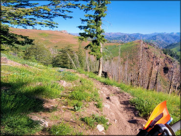
Photo Submitted 7/23/2022 (Thanks!)
Greenhorn Trail Photo
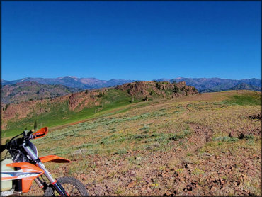
Photo Submitted 7/23/2022 (Thanks!)
Greenhorn Trail Photo
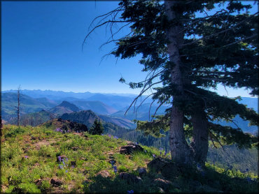
Photo Submitted 7/23/2022 (Thanks!)
Greenhorn Trail Photo
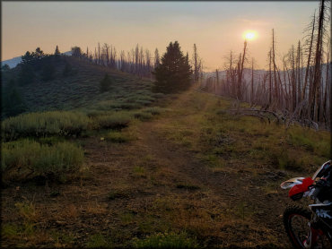
Photo Submitted 12/4/2021 (Thanks!)
RIDER COMMENTS & REVIEWS