 |
      |
| Home > Idaho > Caribou Loop Trail |
Caribou Loop Trail
Wednesday, August 20, 2025
| Other Names | Caribou-targhee National Forest, Soda Springs Ranger District, Bridger-teton National Forest, Greys River Ranger District |
| Last Known Status | Open |
This trail system crosses the borders of Idaho into Wyoming and back for a 200 mile loop. The route winds by rugged snow capped mountains, green meadows, creeks, rivers, lakes and a beautiful mixed aspen and pine tree forest. The trail is mostly gravel hard pack with occasional muddy sections and loose chunk rock but was designed to be a leisure type ride, making it perfect for beginners or those on dual sport motorcycles.
The main loop is marked every three miles with a carsonite pole, which makes it easy to stay on the designated route. The route also has 20 side trails that are wide enough for smaller vehicles that are 50 inches or less in width. There are also five designated staging areas that allow overnight camping plus numerous Forest Service campgrounds along the route that permit direct offroad access.
Since the trail crosses both Idaho and Wyoming state lines, visitors need to obtain both Idaho and Wyoming offroad stickers.
REGULATIONS
| Permit Required | Yes | Idaho OHV Registration Sticker and WY ORV Sticker |
| Dates Open | June through late fall | |
| Other ATV Stickers Accepted | No | A non-resident registration sticker must be purchased. (As of January 2020, Idaho no longer honors stickers from other states.) |
| Spark Arrestor | Yes | A spark arresting exhaust silencer or end cap is required for all vehicles. |
| Noise Limit | ||
| Whip Flags | Not Required | |
| Maximum Vehicle Width | Yes (66 inches) | has entrance gate or posts |
 Motorcycles & Dirt Bikes Motorcycles & Dirt Bikes | Permitted | |
 ATVs ATVs | Permitted | |
 UTV & SXS UTV & SXS | Permitted | (maximum width 66 inches) |
 4x4 & Jeeps (registered) 4x4 & Jeeps (registered) | Prohibited | |
| Dune Buggy & Sand Rail 4x4 (unregistered) | Prohibited | |
| 2 Stroke Engines | No Restriction | |
 Camping Camping | Some Areas | (camp in developed sites only) |
 Campfires Campfires | ||
| Night Riding | Unknown | |
| Trail Blazing | Prohibited | riders must stay on trail |
| Rule Enforcement |
TYPE OF AREA
| Area | Motorized Trails |
| Land | National Forest |
FEES & PASSES
| Parking | (None) |
| Entry | (None) |
| Riding | (None) |
| Camping | (None) |
RATINGS
| Our Rating |  Good Good |
| Recommended Stay | 1-2 Days |
| Comments | (Scroll Down For Rider Reviews & Comments) |
DRIVING DIRECTIONS
| Nearest City | Soda Springs, ID | ||
| Address | Tincup Road, Wayan, ID 83285 | ||
| From: Soda Springs, ID
For Tincup/Bridge Creek Staging Area: 1) Take Hwy 34 North about 43 miles 2) Turn left on Tincup Road, stage here. From Alpine, WY: For McCoy Creek/Hwy 89 Staging Area: 1) Take Hwy 89 South about 3 miles 2) Staging area is on the right (west). For Alpine/Greys River Staging Area: 1) From Hwy 89 take Trail Drive east about 1 mile 2) Staging area is on the left. For Smith Fork Staging Area: 1) Take Hwy 89 South about 45 miles 2) Turn left (east) onto FS Road 10072/Smith Fork Road 3) Continue .4 miles 4) Staging area is on the left. |

OFFICIAL CONTACTS
| Contact Info | Caribou-targhee National Forest, Soda - Springs Ranger District 1405 Hollipark Drive Idaho Falls, ID 83401 (208) 557-5900 mailroom_r4_caribou_targhee@fs.fed.us www.fs.usda.gov |
| Contact Info | Bridger - Teton National Forest - Greys River Ranger District 671 North Washington Street Afton, WY 83110 (307) 886-5300 r4_b-t_info@fs.fed.us www.fs.usda.gov |
| Contact Info | Caribou Loop Trail 159 S Main Soda Springs, ID 83276 (208) 317-7289 info@cariboulooptrail.com cariboulooptrail.com |
Caribou Loop Trail Photo
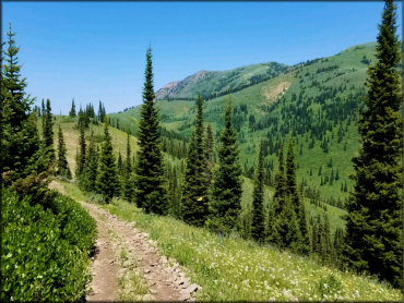
Photo Submitted 12/7/2020 (Thanks!)
ADD PHOTOS
TERRAIN
| Miles Of Trail | 200 | |
| Climate Type | Forest | |
| Elevation | 5600 to 9300 ft. | |
| Trail Maintenance | Marked, Not Rated, Heavily Maintained | |
| Loose Dirt |  Little Little | |
| Hard Pack |  Mostly Mostly | |
| Sand |  None None | |
| Mud | Little | |
| Dust | Little | |
| Rocks | Little | |
| Trees |  All All | |
| Steep Hills |  Some Some | |
| Water Crossings |  Few Few | |
| Small Jumps | None | |
| Large Jumps | None | |
| Berms | None | |
| Sand/Gravel Pits | None | |
| Single Track | None | |
| Roads | Mostly | |
| Shade |  Many Many | |
| Hazards | Few | (hazards assumed marked but use caution) |
 Novice Novice | Mostly | |
 Amateur Amateur | Little | |
 Expert Expert | None |
GPS POINTS

KEY SERVICES
 Gasoline Gasoline | 5-20 Miles (E) | see trail map |
| Diesel | 5-20 Miles (E) | see trail map |
 Water Water | On Site | see trail map |
 RV Hookup RV Hookup | 5-20 Miles (E) | see trail map |
 RV Disposal RV Disposal | 5-20 Miles (E) | see trail map |
| Campground | On Site | see trail map |
 Conv Store Conv Store | 5-20 Miles (E) | see trail map |
RIDER COMMENTS & REVIEWS