 |
      |
| Home > Massachusetts > Pittsfield State Forest |
Pittsfield State Forest
Thursday, April 30, 2026
| Other Names | Balance Rock State Park, Potter Mountain, Churchill Brook Trail, Skyline Trail, Taconic Skyline Trail, Snake Brook Trail |
| Last Known Status | Open |
Pittsfield State Forest has about 16 miles of ATV trails that wind through a mixed hardwood forest. Most of the trails are fast and smooth and are marked with orange and yellow triangle blazes on the trees.
Free trail maps can be obtained by visiting the ranger station on Cascade Street and Shamrock Blvd but there is no access to the trails from this location since all of the trails here are for hiking or mountain bike use. Balance Rock and Potter Mountain Staging areas are the only two parking areas that provide direct access to the ATV trails (Balance Rock has plenty of parking for larger trailers while Potter Mountain is better suited for smaller vehicles).
The forest offers three campgrounds to choose from but there is no direct trail access, so machines must be hauled to and from the staging areas. The Lulu Brook Day Use Area has numerous BBQ grills and picnic tables. Forest hours are from sunrise to 8pm, year-round. Snowmobiles are permitted during winter months.
REGULATIONS
| Permit Required | Yes | Massachusetts Registration Sticker |
| Dates Open | May through the last Sunday in November | |
| Other ATV Stickers Accepted | No | ATVs and motorcycles must be registered in Massachusetts, no reciprocity with other states. |
| Spark Arrestor | Yes | A spark arresting exhaust silencer or end cap is required for all vehicles. |
| Noise Limit | Yes (96 dB) | |
| Whip Flags | Not Required | |
| Maximum Vehicle Width | Yes (50 inches) | has entrance gate or posts vehicles under 900lbs dry weight and 50 inches wide permitted |
 Motorcycles & Dirt Bikes Motorcycles & Dirt Bikes | Permitted | |
 ATVs ATVs | Permitted | (maximum width 50 inches) |
 UTV & SXS UTV & SXS | Permitted | (maximum width 50 inches) |
 SUVs & Jeeps (registered) SUVs & Jeeps (registered) | Prohibited | |
| Dune Buggy & Sand Rail 4x4 (unregistered) | Prohibited | |
| 2 Stroke Engines | No Restriction | |
| MX Helmet Required | Yes | required by state law |
 Camping Camping | Some Areas | (camp in developed sites only) permitted at Bishop Field, Parker Brook & Berry Pond Campgrounds |
 Campfires Campfires | Some Areas | (permitted in developed campsites only) |
| Night Riding | No | |
| Trail Blazing | Prohibited | stay on trail |
| Alcohol | Prohibited | |
| Rule Enforcement | Many | On-Site Office/Station Gate Inspection |
TERRAIN
| Approx Size | 9,600 acres (15 sq mi) | |
| Miles Of Trail | 16 | |
| Climate Type | Forest | |
| Elevation | 1200 to 2000 ft. | |
| Trail Maintenance | Marked, Not Rated, Lightly Maintained | Trails are marked with orange and yellow blazes. |
| Loose Dirt |  Little Little | |
| Hard Pack |  Mostly Mostly | |
| Sand | Little | |
| Mud | Little | |
| Dust | Little | |
| Rocks |  Some Some | |
| Trees |  All All | |
| Steep Hills |  Few Few | |
| Water Crossings | Few | |
| Small Jumps |  None None | |
| Large Jumps | None | |
| Berms | Few | |
| Sand/Gravel Pits | None | |
| Intersections | Some | |
| Rider Traffic | Few | |
| Shade | Some | |
| Ranges/Gunfire | Some | area open during hunting season |
| Hazards | Few | (hazards not marked) |
 Novice Novice | Mostly | |
 Amateur Amateur | Some | |
 Expert Expert | Little |
TYPE OF AREA
| Area | Motorized Trails |
| Land | State Forest, State Park |
GPS POINTS


KEY SERVICES
 Gasoline Gasoline | 1-5 Miles (SE) | Exxon/Mobil (413) 499-1416 |
| Diesel | 1-5 Miles (SE) | Exxon/Mobil (413) 499-1416 |
 Water Water | 1-5 Miles (SE) | Hidden Valley Campground (413) 447-9419 or (877) 392-2267 |
 RV Hookup RV Hookup | 1-5 Miles (SE) | Bonnie Brae Cabins & Campsites (413) 442-3754 or (413) 445-9358 |
 RV Disposal RV Disposal | 1-5 Miles (SE) | Bonnie Brae Cabins & Campsites (413) 442-3754 or (413) 445-9358 |
| Campground | On Site | Berry Pond and Parker Brook Campground (413) 499-5112 |
 Conv Store Conv Store | 1-5 Miles (SE) | Getty Food Mart (413) 499-9271 |
FEES & PASSES
| Parking | Yes ($5.00) Pittsfield State Forest Day Use Fee - $5/day/residents; $20/day/non-residents. Residency determined by vehicle license plate. |
| Entry | (None) |
| Riding | (None) |
| Camping | Yes Tent: $17.00 RV: $17.00 Addtl. Vehicle: $0.00 Pittsfield State Forest Campground Fee - $17/night/residents; $54/night/non-residents. Residency determined by vehicle license plate. |
RATINGS
| Pros | scenic forest |
| Cons | small area, additional permit required to ride trails |
| Our Rating |  Good Good |
| Recommended Stay | Half Day |
| Comments | (Scroll Down For Rider Reviews & Comments) |
DRIVING DIRECTIONS
| Nearest City | Pittsfield, MA | ||
| Address | Shamrock Blvd, Pittsfield, MA 01201 | ||
| From: Pittsfield, MA
1) Head west on West Street about 2 miles 2) Turn right (north) on Churchill Street, continue 1.7 miles 3) Turn left (west) on Cascade Street, continue .7 miles 4) Turn right (north) on Shamrock Blvd, continue about .5 miles 5) Ranger station is on the left (west).* *Note: The above directions are to the ranger station to obtain the daily riding permit. To access the ATV trails you must stage at either Balance Rock or Potter Mountain Road Staging Area. For Potter Mountain Staging Area: 6) Leave ranger station by heading south on Shamrock Blvd about 1 mile 7) Turn left (east) on Cascade Street, continue .5 miles 8) Turn left (north) on Churchill Street, continue 2.1 miles 9) Turn left (west) on Potter Mountain Road, continue .4 miles For Balance Rock Staging Area: 10) Turn right (east) on Potter Mountain Road, continue .4 miles 11) Look for gate and sign for Balance Rock State Park on the left (west), turn here. 12) Continue about .5 miles toward staging area. |


OFFICIAL CONTACTS
| Contact Info | Pittsfield State Forest 1041 Cascade Street Pittsfield, MA 01201 (413) 442-8992 pittsfield.forest@state.ma.us www.mass.gov |
| Contact Info | Massachusetts Environmental Police 251 Causeway Street, Suite 101 Boston, MA 02114 (617) 626-1610 www.mass.gov |
| Comment | ATV/Motorcycle Registration Info |
| Contact Info | Reserve America (877) 422-6762 (877) 620-2267 www.reserveamerica.com |
| Comment | Campground Reservations |
| Contact Info | Patriots All Terrain Club P.O. Box 2967 Pittsfield, MA 01201 patriotsatv@yahoo.com www.patriotsatv.org |
| Comment | Offroad club that does trail maintenance and group rides in Massachusetts and surrounding states. |
Pittsfield State Forest Trail Photo
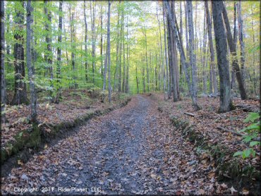
Most of the ATV trails look like this - smooth and flat.
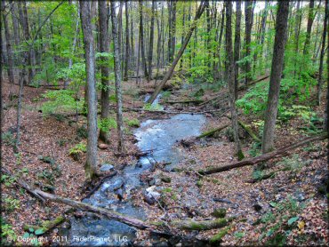
Pittsfield State Forest Trail Photo
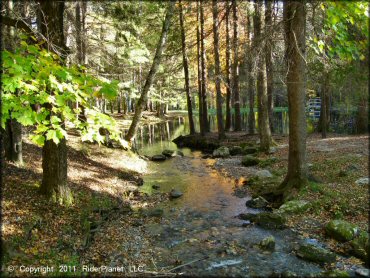
Lulu Brook
Pittsfield State Forest Trail Photo
There are a few berms to be found here.
Pittsfield State Forest Trail Photo
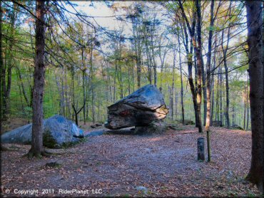
Balance Rock, a 165-ton limestone boulder.
Pittsfield State Forest Trail Photo
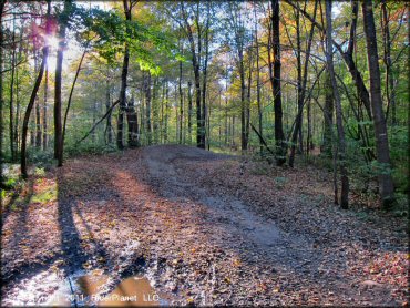
The trails can get a little muddy during wet weather.
Pittsfield State Forest Trail Photo
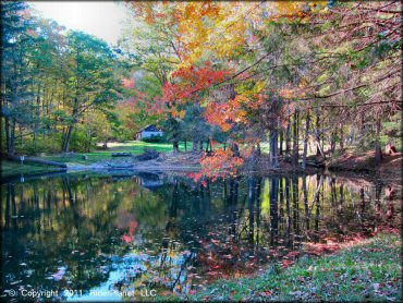
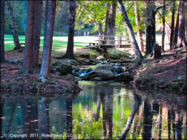
The Lulu Brook Day Use Area offers a pleasant looking pond and plenty of picnic sites. ATV parking and swimming is not permitted here.
Pittsfield State Forest Trail Photo
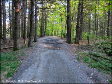
Most of the trails are flat and smooth, making it a good choice to bring a beginner.
Pittsfield State Forest Trail Photo
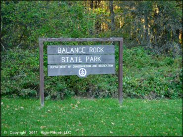
The Balance Rock State Park sign marks the main entrance to the eastern staging area.
Pittsfield State Forest Trail Photo
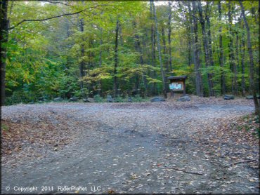
The Potter Mountain Staging Area offers a small but level parking area and a map kiosk.
Pittsfield State Forest Trail Photo
Lulu Brook Day Use Area
Pittsfield State Forest Trail Photo
Another smooth section of trail.
Pittsfield State Forest Trail Photo
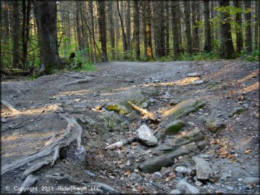
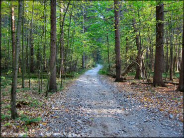
One of the few sections of the trail that is slightly rocky.
Pittsfield State Forest Trail Photo
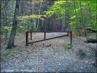
This is the trailhead at Balance Rock. ATVs must be less than 50 inches wide to pass around the gate.
Pittsfield State Forest Trail Photo
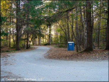
There are no services at Balance Rock Staging Area except for a vault toilet so come prepared.
Pittsfield State Forest Trail Photo
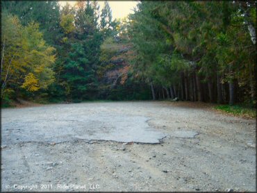
Balance Rock Staging Area provides plenty of turnaround room and level parking for larger vehicles.
Pittsfield State Forest Trail Photo
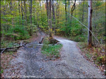
One of the bridge crossings.
Pittsfield State Forest Trail Photo
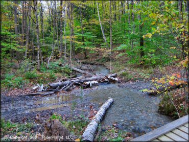
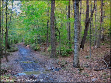
Water crossing on main trail from Balance Rock.
Pittsfield State Forest Trail Photo
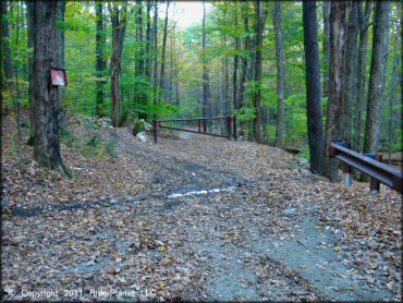
The trailhead at Potter Mountain is open to machines less than 50 inches wide. As you can see, the trail veers left and around the gate.
Pittsfield State Forest Trail Photo
RIDER COMMENTS & REVIEWS