 |
      |
| Home > Oregon > Mcgrew Trail |
Mcgrew Trail
Friday, October 3, 2025
| Other Names | O'brien, Siskiyou National Forest, Grants Pass, Oregon Caves, Sourdough, Sourdough Camp, Mcgrew 4wd Trail, Rock Creek, Elk Creek, Illinois River, Biscuit Creek, Cedar Springs |
| Last Known Status | Variable Schedule (special use permit required) |
This is a remote area that mainly consists of gravel roads and 4x4 trails. The climbs are gradual (not too steep) but some sections of the trail are pretty rocky. There is a nice staging and camping area next to the stream on the left main entrance at N42.01.615 W123.46.079. You can stage here or drive further. Follow the main road up the mountain, past the gravel pit, and bear right at the fork (go through the yellow gate) and look for a large unmarked open area on the right. This is the actual trailhead.
The trail is primarily traveled from east to west, ending near Sourdough Camp. Sourdough Camp can also be reached by heading about five miles south past McGrew Trailhead on Lone Mountain Road and taking the turnoff for NF-4402/Wimer Road heading west.
Visitors should be aware that this trail is only open to OHVs with a special use permit. The trail also has seasonal closures to help reduce the spread of Port Orford Cedar Root Disease. Those looking for rocky 4x4 trails that don't require a special use permit should check out Rattlesnake Ridge, which is about an hour south off 199. Dirt bike riders should check out High Dome or Elk Camp Ridge.
Some other recommended activites in the area are the Oregon Caves National Monument (north on 199), and the redwood forest (10-15 miles south on 199).
REGULATIONS
| Permit Required | Yes | Oregon ATV Permit stickers required |
| Dates Open | Special use permit required - contact Siskiyou National Forest for details. | |
| Other ATV Stickers Accepted | Yes | An operating permit issued for another state will be honored, but only if the issuing state also honors Oregon operating permits. (As of October 1, 2021, Oregon no longer honors stickers from Washington.) (AZ, CA, ID, IN, MO, NV, PA, SC, UT, VT) |
| Spark Arrestor | Yes | A spark arresting exhaust silencer or end cap is required for all vehicles. |
| Noise Limit | Yes (99 dB) | Oregon ATV noise limits apply (all vehicles limit 99 dB) |
| Whip Flags | Not Required | |
| Maximum Vehicle Width | No Restriction | |
 Motorcycles & Dirt Bikes Motorcycles & Dirt Bikes | Certain Times | special use permit required |
 ATVs ATVs | Certain Times | special use permit required |
 UTV & SXS UTV & SXS | Certain Times | special use permit required |
 4x4 & Jeeps (registered) 4x4 & Jeeps (registered) | Certain Times | special use permit required |
| Dune Buggy & Sand Rail 4x4 (unregistered) | Some Areas | Oregon ATV Permit stickers required special use permit required |
| 2 Stroke Engines | Certain Times | special use permit required |
| MX Helmet Required | Youth Only | required for persons under 18 by state law (RiderPlanet strongly recommends helmets for all riders.) |
 Camping Camping | No Restriction | (camp anywhere) |
 Campfires Campfires | No Restriction | |
| Night Riding | Unknown | |
| Trail Blazing | Prohibited | no trailblazing |
| Alcohol | No Restriction | |
| Rule Enforcement | Few/Periodic |
TERRAIN
| Approx Size | 384,000 acres (600 sq mi) | |
| Miles Of Trail | 29 | |
| Climate Type | Forest | |
| Elevation | 1666 to 3940 ft. | |
| Trail Maintenance | Not Marked, Not Rated, Not Maintained | |
| Loose Dirt |  Little Little | |
| Hard Pack |  Some Some | |
| Sand | Little | |
| Mud | Little | |
| Dust | Some | |
| Rocks |  Mostly Mostly | |
| Trees |  All All | |
| Steep Hills |  Few Few | |
| Water Crossings | Few | |
| Small Jumps | Some | |
| Large Jumps |  None None | |
| Berms | None | |
| Sand/Gravel Pits | Few | |
| Single Track | None | |
| Roads | Mostly | |
| Intersections | Few | |
| Rider Traffic | Few | |
| Shade |  Many Many | |
| Ranges/Gunfire | None | |
| Hazards | Few | (hazards not marked) |
 Novice Novice | Some | |
 Amateur Amateur | Mostly | |
 Expert Expert | Little | |
| Comment | mostly gravel roads & rocky jeep trails | |
TYPE OF AREA
| Area | Motorized Trails, Gravel Pit |
| Land | National Forest |
GPS POINTS


KEY SERVICES
 Gasoline Gasoline | 5-20 Miles (N) | Chevron (541) 592-3080 |
| Diesel | 5-20 Miles (N) | Chevron (541) 592-3080 |
 Water Water | 1-5 Miles (NE) | Mountain Man RV Park (541) 592-2656 |
 RV Hookup RV Hookup | 1-5 Miles (NE) | Mountain Man RV Park (541) 592-2656 |
 RV Disposal RV Disposal | 1-5 Miles (NE) | Mountain Man RV Park (541) 592-2656 |
| Campground | On Site | |
 Conv Store Conv Store | 5-20 Miles (N) | Speedy Mart & Deli (541) 592-2814 |
FEES & PASSES
| Parking | (None) |
| Entry | (None) |
| Riding | (None) |
| Camping | (None) |
RATINGS
| Pros | very remote, good scenery, nearby sight seeing, swimming/fishing holes, free camping |
| Cons | rocky, mostly gravel roads & jeep trails |
| Our Rating |  Very Good Very Good |
| Recommended Stay | Full Day |
| Comments | (Scroll Down For Rider Reviews & Comments) |
DRIVING DIRECTIONS
| Nearest City | O'Brien, OR | ||
| Address | Lone Mountain Road, O'Brien, OR 97534 | ||
| From: Grants Pass, OR
1) Take 199 South to O'Brien (very small town) 2) Take a right in the middle of town 3) Turn right (west) on Lone Mountain Road (Country Road #5550) 4) Proceed approx 4 miles to National forest entrance - stage anywhere 5) Main trail head is another 5-6 miles ahead - veer right on 4402-19 fork - continue up hill to open area (trail head clearing). |


OFFICIAL CONTACTS
| Contact Info | Siskiyou National Forest - Wild Rivers Ranger District 26568 Redwood Hwy Cave Junction, OR 97523 (541) 592-4000 (541) 471-6500 kristin.ballard@usda.gov www.fs.usda.gov |
| Contact Info | Oregon ATV Safety Education Card (877) 772-3359 atv.info@state.or.us www.oregon.gov |
| Contact Info | Oregon State Parks Online Store 725 Summer Street NE, Suite C Salem, OR 97301 (800) 551-6949 park.info@oregon.gov store.oregonstateparks.org |
Mcgrew Trail Photo
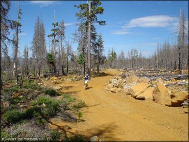
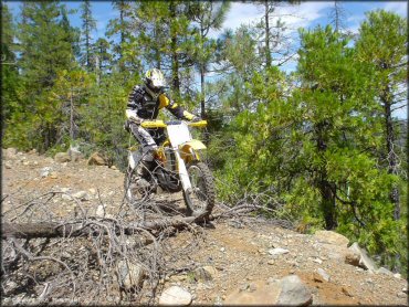
This photo was taken near the main trailhead. The road is wide and fairly easy to start. It gets a little bit more narrow and rocky as you go but nothing too challenging.
Mcgrew Trail Photo
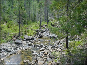
You will cross over this small stream on the way in. Great scenery, crystal clear water.
Mcgrew Trail Photo
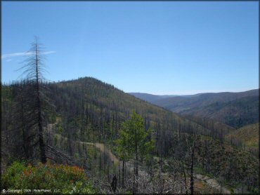
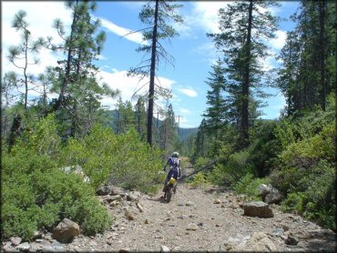
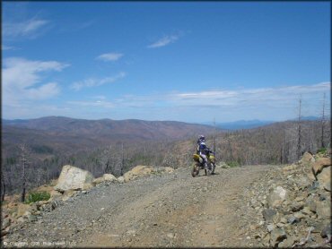
One of many scenic panoramic views to be had from the main trail. First time ATV riders could have a blast.
Mcgrew Trail Photo
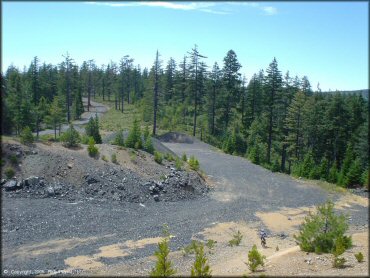
There is a small gravel pit or play area along the main road.
Mcgrew Trail Photo
There are numerous side roads that dead end quickly. After taking a couple you'll realize that none of them go anywhere.
Mcgrew Trail Photo
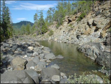
This small creek is the perfect place to cool off, but watch out for the crayfish that lurk at the bottom! You can stage very near where this photo was taken.
Mcgrew Trail Photo
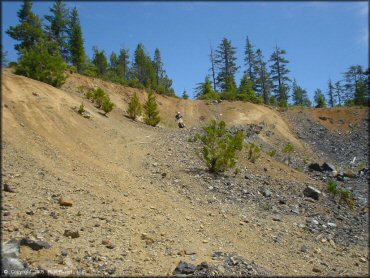
Another shot of the play area at the gravel pit. It was fun enough to mess around for a few minutes.
Mcgrew Trail Photo
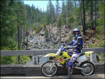
This is a bridge crossing for the stream along the main road. We didn't know the area so we staged right near the entrance.
Mcgrew Trail Photo
Some of the side roads get very little traffic. There were alot of downed trees and dead ends.
Mcgrew Trail Photo
This is a view from the hill top at the gravel pit. You can see the main road in the distance.
Mcgrew Trail Photo
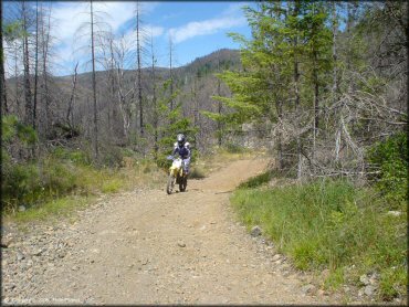
Smooth and easy, these are great trails for beginners or ATV sight seeing.
Mcgrew Trail Photo
This was a typical fun section in the first mile of the main trail. Lots of turns with slight climbs and dips. Not too many rocks.
Mcgrew Trail Photo
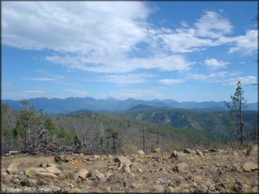
Another scenic view from the main road.
Mcgrew Trail Photo
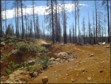
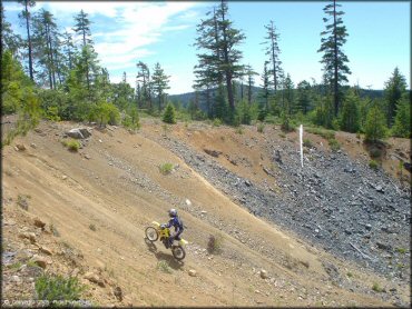
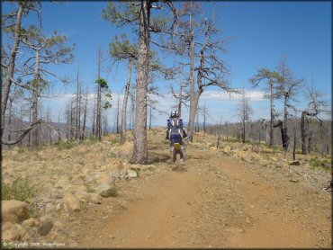
Some sections of the trail are a bit rocky. It gets rockier than this too, but not really difficult or steep.
Mcgrew Trail Photo
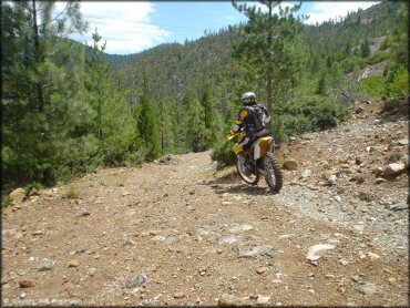
This place may not be the single track twisty that you were hoping for but still, it is a gorgeous ride.
Mcgrew Trail Photo
The area is so remote that many of the roads get little trafffic.
RIDER COMMENTS & REVIEWS