 |
      |
| Home > Washington > Tahuya State Forest |
Tahuya State Forest Trail System
Saturday, May 10, 2025
| Other Names | Mission Creek, Stoffer Trail, Northwest Trail, Jones Road, Goat Ranch Pond, Long Marsh, Elfendahl Pass Road, Little Tahuya Creek, Camp Spillman, Kamenga Canyon, Tahuya River Horse Camp, Kamenga Bridge, Suckell Pond, Twin Lakes, Collins Lake, Erdman Lake, Haven Lake, Wooten Lake, Sand Hill Pit, Scarification Pond, Dewatto River, South Puget Sound Region, Tahuya State 4x4 Park, Mission Creek ATV Trails |
| Last Known Status | Open |
Open year-round, this state forest offers about 170 miles of multiple-use deep woods trails and a large gravel/play pit. The trails can get dusty during summer months but offer great riding during the rainy season. Riders should note that most of the trails are limited to machines that are 48" or less in width but larger vehicles are permitted on the 4x4 trail. (This area is a HUGE and a Rino or Chatterbox is recommended.)
The forest has two designated staging areas (Mission Creek and Elfendahl Pass) and several primitive campgrounds with access to beginner friendly trails. Reservations are no longer required at Tahuya River Horse Camp but there are designated non-motorized only weekends so call first before heading out.
Visitors should note that if you have a street legal dual sport motorcycle or 4x4 you need to pick up a Discover Pass prior to entry.
REGULATIONS
| Permit Required | Yes | WA ORV Tab and Washington Discover Pass** |
| Dates Open | Year-Round | |
| Other ATV Stickers Accepted | Unknown | |
| Spark Arrestor | Yes | A spark arresting exhaust silencer or end cap is required for all vehicles. |
| Noise Limit | Yes (105 dB) | |
| Whip Flags | Not Required | |
| Maximum Vehicle Width | Yes (48 inches) | has entrance gate and narrow terrain |
 Motorcycles & Dirt Bikes Motorcycles & Dirt Bikes | Permitted | |
 ATVs ATVs | Some Areas | (maximum width 48 inches) |
 UTV & SXS UTV & SXS | Some Areas | (maximum width 48 inches) permitted on 4x4 trail |
 4x4 & Jeeps (registered) 4x4 & Jeeps (registered) | Some Areas | permitted on 4x4 trail |
| Dune Buggy & Sand Rail 4x4 (unregistered) | Some Areas | (maximum width 48 inches) permitted on 4x4 trail |
| 2 Stroke Engines | No Restriction | |
 Camping Camping | Some Areas | (camp in developed sites only) camping is not permitted in the day use areas |
 Campfires Campfires | Some Areas | (permitted in developed campsites only) |
| Night Riding | No | riding permitted during daylight hours |
| Trail Blazing | Some Areas | permitted in sand pit play area |
| Rule Enforcement | ||
| Comment | **A Discover Pass is not required on any vehicle with a current ORV permit/tab but is required for the street-legal vehicle that is used to transport the ORV. If using a trailer an additional pass is not required. | |
TERRAIN
| Approx Size | 23,000 acres (36 sq mi) | |
| Miles Of Trail | 170 | |
| Climate Type | Forest | |
| Elevation | 250 to 500 ft. | |
| Trail Maintenance | Marked, Not Rated, Heavily Maintained | |
| Loose Dirt |  Little Little | |
| Hard Pack |  Mostly Mostly | |
| Sand |  None None | |
| Mud |  Some Some | |
| Dust | Some | dusty during summer months |
| Rocks | Little | |
| Trees |  All All | |
| Steep Hills | Some | |
| Water Crossings |  Few Few | |
| Large Jumps | None | |
| Berms | Few | |
| Sand/Gravel Pits | Few | thick gravel at Sand Hill Pit |
| Single Track | Some | |
| Roads | Few | |
| Intersections | Some | |
| Rider Traffic | Some | |
| Shade | All | |
| Hazards | Few | (hazards assumed marked but use caution) |
 Novice Novice | Little | campgrounds are close to beginner friendly trails |
 Amateur Amateur | Some | |
 Expert Expert | Some |
TYPE OF AREA
| Area | Motorized Trails, Gravel Pit |
| Land | State Forest |
GPS POINTS


KEY SERVICES
 Gasoline Gasoline | 1-5 Miles (NE) | Belfair Grocery (360) 275-2754 |
| Diesel | 1-5 Miles (NE) | Belfair Grocery (360) 275-2754 |
 Water Water | 1-5 Miles (SE) | Belfair State Park (888) 226-7688 |
 RV Hookup RV Hookup | 1-5 Miles (SE) | Belfair State Park (888) 226-7688 |
 RV Disposal RV Disposal | 1-5 Miles (SE) | Belfair State Park (888) 226-7688 |
| Campground | On Site | |
 Conv Store Conv Store | 1-5 Miles (NE) | Safeway (360) 275-0922 |
FEES & PASSES
| Parking | (None) |
| Entry | (None) |
| Riding | (None) |
| Camping | (None) |
| Comment | Discover Pass - $35/annual, daily - $11.50 |
RATINGS
| Our Rating |  Very Good Very Good |
| Recommended Stay | 1-2 Days |
| Comments | (Scroll Down For Rider Reviews & Comments) |
DRIVING DIRECTIONS
| Nearest City | Belfair, WA | ||
| Address | Elfendahl Pass Road, Belfair, WA 98528 | ||
| From: Olympia, WA
For Mission Creek Staging Area: 1) Take US-101 North 17 miles to Exit for SR-3 2) Turn right (north) on SR-3, continue 2.6 miles 3) Turn right (east) on Railroad Avenue, continue 1 block 4) Turn left (north) on Front Street, continue .2 miles 5) Turn right (east) on Pine Street/SR-3, continue 23.4 miles 6) Turn left (north) on Old Belfair Hwy., continue .2 miles 7) Turn left (west) on SR-300, continue 3.1 miles 8) Turn right (north) on Belfair Tahuya Road, continue 1.1 miles 9) Staging area is on the right (north). For Elfendahl Pass Staging Area: 10) Continue west on Belfair Tahuya Road .7 miles 11) Turn right (north) onto Elfendahl Pass Road, continue 2.4 miles 12) Staging area is on the right (east). |


OFFICIAL CONTACTS
| Contact Info | Washington DNR - South Puget Sound Region Office 950 Farman Avenue N Enumclaw, WA 98022 (360) 825-1631 southpuget.region@dnr.wa.gov www.dnr.wa.gov |
| Comment | Press #5 and #1 for trail updates. |
| Contact Info | Washington State Department of Licensing (360) 902-3770 titles@dol.wa.gov www.dol.wa.gov |
| Comment | WA ORV Tab Info |
| Contact Info | Washington Discover Pass (866) 320-9933 licensing@dfw.wa.gov www.discoverpass.wa.gov |
Tahuya State Forest Trail Photo
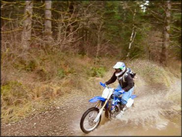
With 170 miles of trails, expect to encounter all types of terrain.
Tahuya State Forest Trail Photo
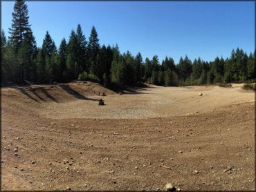
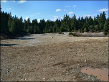
The gravel pit is a popular play area for ATVs.
Tahuya State Forest Trail Photo
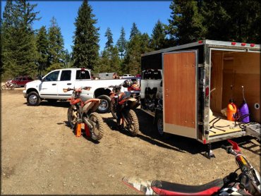
Photo Submitted 10/16/2013 (Thanks!)
Tahuya State Forest Trail Photo
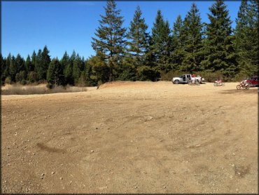
Photo Submitted 10/16/2013 (Thanks!)
Tahuya State Forest Trail Photo
The gravel pit used to be a staging area but the entrance off Sand Hill Road has been gated and closed. The pit is still open for riding and can be reached via existing trails.
RIDER COMMENTS & REVIEWS